


Shower chances return to the forecast today with storms possible beginning Thursday.
Rain chances return to the forecast later this morning and will continue off and on throughout the day. Temperatures climb to near 80 this afternoon with some gusty winds. Tonight, skies will be cloudy as temperature drop to near 70. Patchy fog is possible closer to daybreak.
Today: Spotty showers. Warm and breezy. High: 78.
Tonight: Mostly cloudy. Patchy fog possible. Low: 68.
Thursday: Spotty storms. Gusty winds. High: 83.
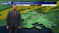
We will see another round of spotty storms around the area Thursday mainly during the afternoon. Friday, a cold front will settle in the area leading to widespread showers and thunderstorms, especially inland. Some of this rain could be heavy and we could see a few stronger storms. This front will stall somewhere in Acadiana. The further north it stalls, the lower our rain chances will be through Sunday. Stay tuned for more information in the days ahead as we fine-tune the details of this forecast. Sunday, the front finally moves through leading to widespread rain chances and possible severe storms. Next week, cooler weather briefly returns to the area with mornings in the 40s and afternoons in the 60s.